
The terms “native” and “near-native” are often too broad to be useful. Provincial borders don’t accurately describe the adapted growing conditions of a species, and we’ve been searching for a better way to identify the plants we grow.
North American Environmental Atlas
Instead of using provincial borders, we have been increasingly relying on the Ecoregion Classification System, created by the Commission for Environmental Cooperation (CEC). In simple terms, this is essentially a multilevel map grouping North America into areas defined by natural geography, and zones of similar growth, similar soil, climate and geology, rather than arbitrary human borders.
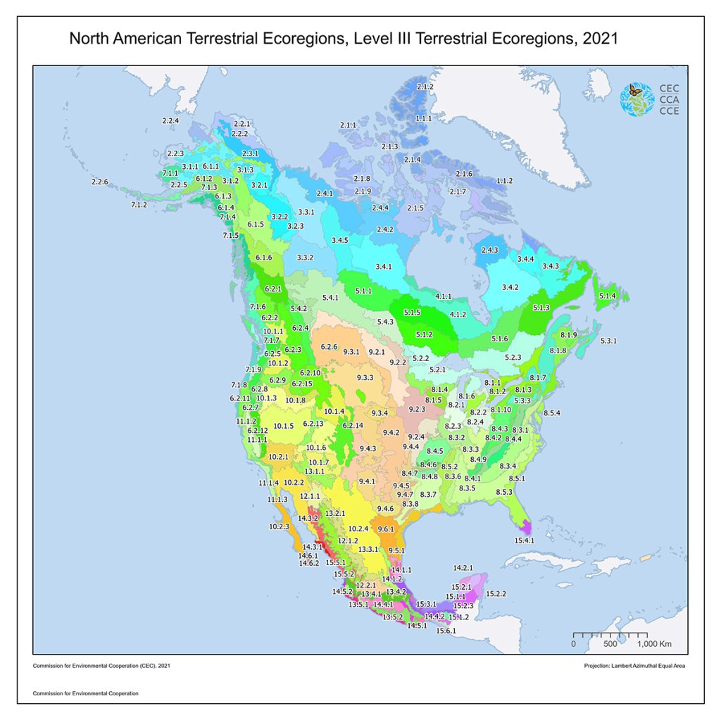
For our location in Aylmer North, the three levels are:
Level I
(Northern Forests)
identifies our broad temperate climate;
Level II
(Atlantic Highlands)
narrowed down to our specific forest type where northern and southern trees meet;
Level III
(Algonquin/Southern Laurentians)
is the hyper-local forest floor, identifying the plants most perfectly adapted to our dirt.
Aylmer, Quebec: An “Ecological Crossroad“
Aylmer North sits at the edge of multiple landscapes, and though our borders are defined by land (and water), we have ecologically diverse immediate neighbours, and also see an overlap of species from the forest and the valley (such as 8.1.1 across the river, the St. Laurence Lowlands where Ottawa is situated).

Localeaf Proximity Scale
Using this information, we are piloting categorizing every plant we grow using a Proximity Scale (0 to +7) based on these continental terrestrial eco-regions, rather than political borders. Look for a blog post in the future explaining why we chose this scale.
How to Read the Scale
Instead of a simple “yes/no” native tag, or arbitrary provincial borders, we are able to use the following scale to understand exactly how locally adapted a plant’s genetics are to our specific dirt where the Boreal Shield meets the Gatineau Valley:
| Score | Label | Description |
|---|---|---|
| 0 | Home | Native to our own ecoregion, the Algonquin/Southern Laurentians — the mixed forests of the Gatineau hills where we grow. |
| 1 | Neighbor | Native to ecoregions directly bordering ours, including the St. Lawrence Lowlands across the river and the Eastern Great Lakes region. |
| 2 | Step Away | Native two ecoregions out from home — still within the broader mixed forest and Appalachian landscape of northeastern North America. |
| 3a | Near Regional | Native to the Eastern Temperate Forests, 3–4 ecoregions away — the same broad forest biome we belong to, covering the Great Lakes interior, the Ozarks, and the southern coastal plain. |
| 3b | Far Regional | Native to the Eastern Temperate Forests but 5 or more ecoregions away — the far edges of our biome, reaching into the south-central plains and east Texas. |
| 4 | Boreal/Prairie | Native to Canada’s taiga and boreal forests, the Hudson Plains, or the Great Plains grasslands — different biomes but with meaningful species overlap due to shared latitude or continental climate. |
| 5 | Continental | Native to North America’s arctic and tundra regions, northwestern mountain ranges, the marine west coast, or the temperate sierras of Mexico. On the continent but from distant, ecologically distinct landscapes. |
| 6 | Eco-Extreme | Native to North American deserts, Mediterranean California, semi-arid highlands, or tropical forests of Mexico and the Gulf coast. On the continent but from biomes with very little ecological overlap with ours. |
| 7 | Global Exotic | Not native to North America. Species originating from other continents. |
Why This Matters – Informed Choice
By choosing a Level 0 plant, you are planting to preserve the specific genetic heritage of the Outaouais. By choosing a Level +3, you might be helping a high-impact species “migrate” in response to warming temperatures. This scale doesn’t tell you what to plant—it gives you the data to decide what role your garden should play in the larger ecosystem. For a friendlier take, read How Local is Localeaf?
We aim to make this information available for every species we are growing this year. You can see this proximity score next to each of the species listed in our Plant Catalogue.
See the list of plants we are growing, with their relative proximity assigned
Methodology and Sources
For every species listed in our database, we began by researching, (using our human brains) the closest referenced historical growing area, prior to colonization, using multiple government indexed and peer reviewed sources. As many of these references are made using alternate location and zone references (ie. national, provincial, etc.), we developed a mapping of each provincial terrestrial zoning system, as well as our national one, to the Commission for Environmental Cooperation standard, to Level III. I would love to eventually use this model to be able to also understand migration patterns and predictions for species, but for now, in version 2.1, we are tracking proximity of species origin only.
With this mapping, we are able to use the support of AI to plot specified locations and translate them into closest CEC Level III Terrestrial region, and from that assign the related Localeaf Proximity Score for any given species.